Does it drive you crazy to see YouTube videos where guys are popping silver coin after silver coin, or relic after relic out of the ground?
 Do you wish that you could find hot places like these where you can go metal detecting?
Well let me tell you, finding the best places to metal detect usually doesn’t happen by chance. It often takes some hard work and a lot of research to find that virgin ground that holds the coins or relics you are searching for.
There is nothing wrong with heading out to your local park or school to do a little detecting. I often find myself in these exact places, but I have to say that I typically lower my expectations when hunting these grounds.
Why? Because they have most likely already been picked over by other people who have detected on those same spot numerous times before. These spots often will yield a lot of modern clad coins and the occasional piece of jewelry. This can still be a lot of fun, but if I had my choice I would rather spend that time swinging my coil over grounds that haven’t been hunted out.
So how do you find these virgin grounds to hunt on? You think out of the box, that’s how. You go where other metal detectorists don’t go. You do your research and find those forgotten places where people used to congregate.
Before I get to the “thinking out of the box stuff”, I have to say that old private homes and property are some great places to start. This is a no-brainer, but I have to mention it before someone comments that I left this out. Reach out to everyone you know that owns old property and ask for permission. This is much easier and takes a lot less guts to do than knocking on a stranger’s door. To get permission from a stranger, you may have to offer to split your finds with them. This often isn’t the case with people you already know.
When I am not metal detecting, I am often spending time doing research on finding the best places to metal detect. The Internet offers some great resources that allow you to do this research much more easily.
I’m going to share a few of the web sites/tools that I leverage when I am searching for new places to hunt. These tools all give you a look back into historical maps, and they are all Free.
All the links below will open in a new window, so feel free to explore them as you read through the information below. Then I’ll go into a few creative ways to find locations to research.
Now before I go any further, I have to reinforce the fact that you should have permission before going onto any private property. This is one of the rules in the metal detecting code of ethics, which hopefully everyone is following.
I hope that you will find these helpful.
- HistoricAerials.com ( <– Link )
This is one of the tools that I use most frequently when researching a hot tip. You can enter an address and it will show you adjustable satellite image maps of the area. I have seen these dating back as far as 1949.
You also have the ability to display topographic maps. Street coordinates have already been lined up, so these maps are fairly accurate. I have seen these topographic maps dating back to 1898.
On both of these map types, you can overlay cities, counties, all roads, and major roads. When you compare the locations on the map with the overlays of modern day roads, you can really pin point your search area.
The magic with HistoricAerials.com comes with its ability to compare two different maps. These can be the satellite vs topographic, satellite vs satellite, etc. You can slide between the two images or fade between the images. Comparing the maps in these ways makes it easy to find locations where old homesteads, schools, churches, or land marks used to exist.
This is a “go to” tool that you will use again and again. - Maps.Google.com ( <– Link )
I’ll still refer to the areas that I am searching with Google Maps. Why? Because the detail is a lot more crisp and clear. And you can drill down on the satellite image until you get to the Google Street View. Google has driven cars all over roads in many countries recording 360 degree images. So you get a street level view in all directions. You can even move down the roads while in Street View just like you are taking a virtual tour.
I love this feature, because it allows me to scout a place out before I ever visit it. I can figure out where I want to park and get a look at the surroundings. You can even get exact directions on how to get there. This is a great tool to use in conjunction with HistoricAerials.com. - Earth.Google.com ( <– Link )
One of the buttons on the tool bar (looks like a clock with an arrow pointing backwards) allows you to show historical imagery. Unfortunately, these images don’t go back very far in time in most cities, so I don’t find it real useful. It is good for current imagery though, and the detail is very good.
So we’ve covered some map tools, let’s look at some good research tools. A lot of these tools and ideas can help you find some places to metal detect that maybe no one else has thought to yet.
- Searching Google for Historical Map Plats
Historical map plats are available online for free in many areas. Plat maps from the 1800’s and early 1900’s can reveal some interesting places to do more research on.
I even recently found one map for my area that listed “Points of Interest”. These are things like old camps, swimming holes, clubs, parks, fishing lakes, playgrounds, etc.
It also includes churches and schools. I can use Google to find out a little more about these places, and then use the check the map utilities above to see if the still exist. If they don’t exist, using the historical maps can help you pin point exactly where they were located.
I was really surprised by the number of schools, churches, and other land marks that no longer exist. In some cases they are empty fields now.
These map plats are a view into the past, and you will be amazed by what some of them expose.
Here is a legend that can help you find and understand what some of the map symbols are: map symbol legend ( <– Link ). - Sanborn Maps
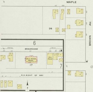 Sanborn maps are some of the most awesome resources that you can use when researching an area to metal detect. I say this because of the level of detail that these maps go into. You can usually find these maps for free on the Internet by doing some Google searches for “Sanborn Map Kentucky”, or “Sanborn Map Shelbyville”, or “Sanborn Map your-city“. I’ve found a few websites that have the Sanborn maps for a number of cities and towns in my state, and I refer to it often.
Sanborn was an American publisher of maps that were initially created to estimate fire and insurance liabilities. They are incredibly detailed and show structures on properties including outhouses and outbuildings. They show the locations of exterior underground cellars, rail stations, creeks, sidewalks, and street names. Sanborn maps contain an index of streets and addresses, a ‘specials’ index with the names of churches, schools, businesses etc., and a master index indicating the entirety of the mapped area. If you have never looked at these Sanborn maps, you definitely need to check them out and compare them against the mapping utilities like HistoricAerials and Google Maps that I mentioned earlier.
You can see just a small section of one of these maps here. Notice that this 1913 map reflects some dark times in our country’s social state and even has a listing for a Negro School. These were all shut down or converted with the end of segregation, and can be excellent spots to investigate. - Historic Newspapers
There is a great resource offered by the U.S. Library of Congress called Chronicling America ( <– Link ). In this project, they have been digitizing newspapers from 1836 – 1922, and you can search for text within these newspapers.
I recommend that you reference the Advanced Search tab on this website to put together some powerful queries about potential places to metal detect. You have the ability to search newspapers for a specific state, or can search only specific newspapers from a particular state. You can then enter search terms to find pages that contain ‘any words’, ‘all of the words’, or a ‘phrase’.Here is an example of how I use this service:
I have family down in Hardinsburg Kentucky which gives me potential access to metal detect in Breckenridge County. It is a small town with a lot of history where everyone knows everyone else. So I can perform a search in the Breckenridge News newspaper for a phrase like “picnic grove”. Any newspapers that contain this phrase will be returned in the search query, and I have the ability to click on that result and read that old article. Better yet, the word(s) or phrase that you searched for is highlighted on the page, so you can easily hone in on exactly what you were searching for.I ran through the search above, on the Breckenridge News, and here is an example of an article that was published in the June 21, 1905 edition of this paper:
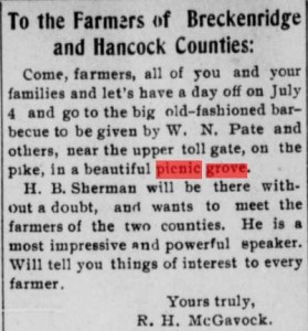 You can see in this article that Mr Pate would host an annual barbeque for all the farmers and their families from a two-country area in a beautiful picnic grove. Now that is a place that I would like to get on with my metal detector. There are some definite unknowns in this example at this point though, like where exactly is this picnic grove? Finding information like this just spawns additional research. At this point, I would pull the plat map from the period, find that upper toll gate, and check that plat for area property owned by the Pate family.
Other pieces of information you will reference are more exact, and spell out specific locations where these events occurred. Many properties and land marks referenced in these old newspapers still stand today, and it can be easy to hone in on these spots.
Then it all comes down to obtaining permission. If the area is public property, then go for it. Else you can reach out to the current land owner to try to arrange permission. If you are armed with this information and have the ability to provide the current land owner with information that your research has produced it can make this conversation much easier.
The number and type of queries that you can run is only limited by your imagination. Here is a list of ideas to get you started: camp, church, circus, event, fish fry, grove, park, picnic, picnic grove, reunion, revival, school, swimming or swimming hole, etc.
I have to warn you that Chronicling America can be an addictive service, and you can spend a lot of time on there. I have often found myself searching for the names of my relatives and reading articles where they were mentioned in the papers.
These old newspapers provide an interesting view back in time, and can shed some light on some great places to do additional research and investigation on. And it is so easy to use once you get the hang of it. This information is golden!

I also want to mention something about the PVA websites. The PVA is the Property Valuation Administrator, and each city/county will have a PVA. You can use the PVAs to find out who owns specific pieces of property, so that you can engage them for permission. You can always blindly knock on a door, but in my opinion it is much better if you know the owners name up front and can address them by name when you introduce yourself.
The PVAs all have their own websites for the most part and will allow you to perform property searches with and address or even as little as a street name. Each parcel of land will be listed and the title holder’s name will be listed as well. If the owner does not live at that location, or the location is an empty lot or tract of land, then their name and address will be listed in the parcel details. Empty lots that had structures on them long ago can be great places to metal detect. The owners often won’t care and be happy to give you permission since it is just an empty lot. Armed with this information, you can be better prepared to reach out to the owner for permission. For an additional fee, you can often do map-based searches, but I find this to be cost prohibitive.
I know this is a long post, so I appreciate you sticking with me this far. There are a number of other ways that I use the Internet to locate places to metal detect. I’ll expand on these in a later post, but I hope that you have found this information helpful. If you know of someone else that is interested in metal detecting and struggling to find places to go, then feel free to share this article with them. You can use the handy buttons below to share the link on Facebook, Tweet the link to your followers, or email the link directly to a friend.
Best of luck and happy digging!
Awesome info. I just searched for those Sanborn maps for my area. The info on them is great and gives me lots of ideas on places to do some more research on. I even found some family property on the map and can see that some buildings used to exist on it that aren’t there now. I’m going to have to check that spot out as soon as the snow melts. Thanks for sharing.